|
Reported Crop Circles for the State
of Oregon -
Pendleton, Umatilla County (July 4, 1998)
A counter-clockwise swirled circle and ring approx. 50 diameter, with the ring being about 3 wide. Located on the downslope of a hill in the field, it was just 200 north of the airports runways at Pendleton Airport, and was first seen by the airports control tower.
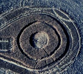 
Crop
type: wheat
Source and photo:
|
|
City
/ County / Date:
- Hubbard,
Marion County, OR
(May 18, 1964)
- Monroe,
Benton County, OR (December 25, 1966)
- Steens Mountain / Mickey Basin / Alvord Desert, Harney County (September
10, 1990)
- Aloha [Sunset Hwy.], Washington County
(June 14, 1994)
- West Union, Washington County (July 20, 1994)
- Gaston, Washington County
(July 26, 1994)
- Hug Point State Recreation Site, Cannon Beach, Clatsop County (September
13, 1994)
- Lebanon, Linn County
(April 30, 1995)
- Portland [Germantown Rd.], Multomah County
(July 27, 1995)
- Lakeview, Lake County
(October 4, 1996)
- Wavr Farm, Salem / Silver Creek Falls, Marion County
(June 28, 1997)
- Pendleton, Umatilla County
(July 4, 1998)
- Whiskey Hill / Hubbard, Clackamas County (July
23, 1998)
- Klamath Falls, Klamath County (October 11, 1998)
- Hubbard, Clackamas County (1999)
- Whiskey Hill / Hubbard / Woodburn, Clackamas County
(August 5, 2000)
- Forest Grove, Washington County (July 4, 2002)
- McMinnville, Willamette Valley, Yamhill County
(May 5-8, 2005)
- Ashland, Jackson County (2007)
|


